

Morocco Strategic Minerals Advances Multiple High-Grade Copper Targets Across its Western High Atlas District
MONTRÉAL, Aug. 20, 2026 (GLOBE NEWSWIRE) -- Morocco Strategic Minerals Corporation. (TSXV: MCC) ("Morocco Strategic Minerals" or the "Company") is pleased to report results from systematic underground and surface channel sampling at Ouneine and a recent batch of selective samples from Tanfit and Ijoukak, as the Company advances drill-target definition across its Western High Atlas District in Morocco.
Highlights
- Ouneine underground Gallery A: 77 channel samples were collected from 15 sections. Eight sections returned more than 1.0% Cu over sampled lengths ranging from 1.6 to 3.0 metres, led by 5.74% Cu and 39 g/t Ag over 2.1 metres, including 13.18% Cu and 88 g/t Ag over 0.9 metre.
- Ouneine surface channel sampling: 34 samples were collected from 13 channels. Six channels returned more than 1.0% Cu, including 1.55% Cu and 199 g/t Ag over 2.0 metres and 1.25% Cu over 4.0 metres.
- Tanfit: Five of six underground grab samples from Gallery 17 returned more than 2.0% Cu, with values of up to 7.76% Cu and 42 g/t Ag. Historical stockpile sampling also returned multiple high-grade copper values, including up to 23.60% Cu and 40 g/t Ag, 22.00% Cu and 50 g/t Ag, and 16.32% Cu and 115 g/t Ag.
- Ijoukak: Fifteen of 16 underground grab samples from the historical 1670- and 1700-level workings returned more than 1.0% Cu. All 11 samples from the 1670 level returned more than 1.0% Cu, including nine above 4.0% Cu and values of up to 27.68% Cu. The 1700-level workings returned values of up to 26.43% Cu and 23.47% Cu. All five historical stockpile samples returned more than 1.0% Cu.
- The results are being integrated with geological and structural mapping to refine and rank priority drill targets across the Western High Atlas District, with systematic channel sampling and three-dimensional interpretation focused on advancing the best-defined targets toward drilling.
Ouneine Underground Channel Sampling
A total of 77 channel samples were collected from 15 sampling sections distributed along the accessible portions of underground Gallery A at Ouneine.
The sampled lengths of the 15 sections range from 1.6 to 3.0 metres. Composite grades were calculated using length-weighted assay values. Copper grades by section range from 0.17% to 5.74% Cu, with eight sections averaging more than 1.0% Cu and three sections averaging more than 2.0% Cu.
The fifteen sections are summarized below:
Table 1 – Ouneine Gallery A Underground Channel Sampling Results
| Section | Sampled Length (m) |
Ag (g/t) | Cu (%) | Included / Higher-Grade Interval |
| Section 1A | 2.00 | 18 | 1.25 | Including 5.38% Cu and 69 g/t Ag over 0.40 m |
| Section 2A | 2.20 | 17 | 1.87 | Including 3.90% Cu and 35 g/t Ag over 1.00 m |
| Section 3A | 1.78 | 5 | 0.38 | Including 1.48% Cu over 0.33 m |
| Section 4A | 2.10 | 39 | 5.74 | Including 13.18% Cu and 88 g/t Ag over 0.90 m |
| Section 5A | 1.75 | 1 | 0.17 | — |
| Section 6A | 1.60 | 2 | 0.31 | — |
| Section 7A | 1.60 | 6 | 1.23 | Including 4.62% Cu over 0.40 m |
| Section 8A | 1.90 | 7 | 1.41 | Including 2.38% Cu over 1.10 m |
| Section 9A | 2.10 | 11 | 2.29 | Including 5.29% Cu over 0.90 m |
| Section 10A | 2.67 | 7 | 0.74 | Including 1.31% Cu over 0.95 m |
| Section 11A | 2.15 | 6 | 0.67 | Including 1.18% Cu over 1.10 m |
| Section 12A | 2.40 | 2 | 0.38 | Including 1.18% Cu over 1.10 m |
| Section 13A | 3.00 | 8 | 1.12 | Including 3.55% Cu over 0.90 m |
| Section 14A | 2.00 | 11 | 2.97 | Including 9.60% Cu over 0.60 m |
| Section 15A | 2.35 | 1 | 0.21 | Including 0.48% Cu over 0.80 m |
The Gallery A plan illustrates that copper mineralization occurs in multiple sections distributed along a substantial portion of the accessible underground workings. Several of the broader mineralized sections contain narrower, higher-grade intervals that are being evaluated as part of the Company’s structural interpretation and drill-targeting work.
The Ouneine licence contains multiple historical underground workings identified as Galleries A, B, C and D. The Company’s initial systematic underground channel program focused on accessible portions of Gallery A.
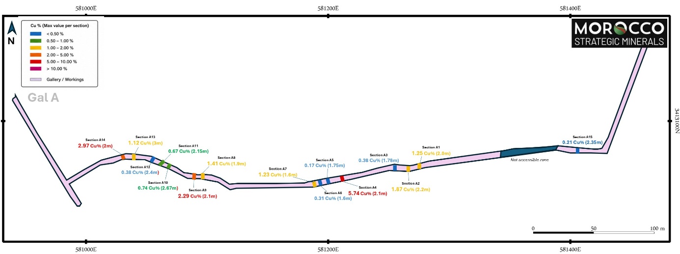
Figure 1: Plan of Ouneine Gallery A showing the locations, sampled lengths and average composite copper grades of each underground channel section.
Ouneine Surface Channel Sampling
A total of 34 channel samples, excluding blank, standard and duplicate quality-control samples, were collected from 13 surface channels at Ouneine.
Six of the 13 surface channels returned composite grades greater than 1.0% Cu. The results confirm locally copper-silver mineralization at surface and provide additional areas for geological and structural follow-up.
Table 2 – Ouneine Surface Channel Sampling Results
The thirteen sections are summarized below:
| Channel | No. Samples | From (m) | To (m) |
Sampled Length (m) |
Ag (g/t) | Cu (%) | Higher-Grade Interval |
| ON-CH1 | 2 | 0.00 | 1.20 | 1.20 | 116 | 0.84 | 1.52% Cu over 0.60 m |
| ON-CH2 | 3 | 0.00 | 2.00 | 2.00 | 199 | 1.55 | 3.07% Cu over 0.60 m |
| ON-CH3 | 3 | 0.00 | 1.40 | 1.40 | 10 | 1.04 | 3.45% Cu over 0.40 m |
| ON-CH4 | 2 | 0.00 | 0.90 | 0.90 | 10 | 0.43 | — |
| ON-CH5 | 3 | 0.00 | 3.00 | 3.00 | 4 | 0.14 | — |
| ON-CH6 | 2 | 0.00 | 1.00 | 1.00 | 4 | 0.59 | — |
| ON-CH7 | 2 | 0.00 | 1.00 | 1.00 | 19 | 1.68 | — |
| ON-CH8 | 3 | 0.00 | 1.00 | 1.00 | 4 | 0.19 | — |
| ON-CH9 | 3 | 0.00 | 2.37 | 2.37 | 33 | 1.61 | 1.86% Cu over 2.04 m |
| ON-CH10 | 3 | 0.00 | 1.70 | 1.70 | 4 | 0.31 | — |
| ON-CH11 | 3 | 0.00 | 2.40 | 2.40 | 15 | 1.33 | 2.02% Cu over 1.50 m |
| ON-CH12 | 3 | 0.00 | 4.00 | 4.00 | 10 | 1.25 | 1.64% Cu over 3.00 m |
| ON-CH13 | 2 | 0.00 | 4.00 | 4.00 | 3 | 0.26 | — |
The surface results provide additional copper-silver targets outside the sampled portion of Gallery A and will be incorporated into the ongoing geological and structural interpretation of the Ouneine licence.
*All underground and surface channel lengths reported in this release are measured sample lengths. The relationship between the sampled lengths and the true widths of the mineralized structures has not yet been determined.
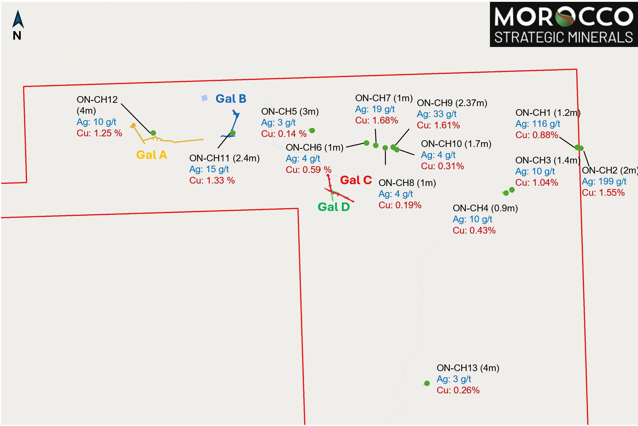
Figure 2: Ouneine surface channel locations and average copper-silver results for each channel sample.
Tanfit and Ijoukak Sampling Results
Additionally, the Company continued to advance its district-wide exploration program with initial exploration sampling at the Tanfit and Ijoukak licences, targeting historical underground workings and associated stockpiles.
At Tanfit, the Company collected selective rock samples from both accessible underground workings and historical stockpiles. Underground sampling at Gallery 17 comprised six grab samples, five of which returned greater than 2.0% Cu. Selected results include:
- TF-17-4, Gallery 17: 7.76% Cu and 42 g/t Ag
- TF-17-1, Gallery 17: 3.22% Cu and 27 g/t Ag
- TF-17-3, Gallery 17: 2.39% Cu and 39 g/t Ag
- TF-17-5, Gallery 17: 2.36% Cu and 12 g/t Ag
- TF-17-6, Gallery 17: 2.01% Cu and 8 g/t Ag
Historical stockpile sampling at Tanfit comprised ten exploration samples from material associated with Levels 50 and 145 and Gallery 17. Eight of the ten samples returned greater than 1.0% Cu. Selected results include:
- TF-SP-50-1, stockpile associated with Level 50: 23.60% Cu and 40 g/t Ag
- TF-SP-17-1, stockpile associated with Gallery 17: 22.00% Cu and 50 g/t Ag
- TF-145-1, stockpile associated with Level 145: 16.32% Cu and 115 g/t Ag
- TF-145-3, stockpile associated with Level 145: 14.97% Cu, 70 g/t Ag and 0.12 g/t Au
- TF-SP-17-2, stockpile associated with Gallery 17: 5.00% Cu and 21 g/t Ag
- TF-SP-17-6, stockpile associated with Gallery 17: 3.02% Cu and 10 g/t Ag
- TF-145-2, stockpile associated with Level 145: 1.79% Cu and 37 g/t Ag
- TF-SP-17-4, stockpile associated with Gallery 17: 1.44% Cu and 10 g/t Ag
In total, 13 of the 16 exploration samples collected from the Tanfit underground workings and historical stockpiles returned greater than 1.0% Cu. The Gallery 17 results support detailed geological and structural mapping and systematic channel sampling of the accessible underground workings to establish the orientation, sampled width and potential continuity of the copper-bearing structures.
At Ijoukak, the Company collected selective rock samples from accessible historical underground workings, surface mineralization and an historical stockpile. Underground grab sampling comprised 16 exploration samples from the historical 1670- and 1700-level workings. All 11 samples collected from the 1670-level workings returned greater than 1.0% Cu, ranging from 1.35% to 27.68% Cu, with nine returning greater than 4.0% Cu. Selected underground results include:
- IJ-1670-11, historical 1670-level workings: 27.68% Cu
- IJ-1700B-3, historical 1700-level workings: 26.43% Cu
- IJ-1700A-2, historical 1700-level workings: 23.47% Cu
- IJ-1670-6, historical 1670-level workings: 13.28% Cu
- IJ-1670-8, historical 1670-level workings: 12.12% Cu
- IJ-1670-10, historical 1670-level workings: 10.81% Cu
- IJ-1670-1, historical 1670-level workings: 8.16% Cu
- IJ-1670-4, historical 1670-level workings: 8.08% Cu
- IJ-1670-3, historical 1670-level workings: 4.82% Cu
- IJ-1670-9, historical 1670-level workings: 4.15% Cu
- IJ-1670-7, historical 1670-level workings: 4.13% Cu
- IJ-1700B-1, historical 1700-level workings: 2.62% Cu
- IJ-1700B-2, historical 1700-level workings: 1.87% Cu
A separate surface grab sample, IJ-GB-1, returned 0.60% Cu.
Historical stockpile sampling at Ijoukak comprised five exploration samples, all of which returned greater than 1.0% Cu, ranging from 1.11% to 2.69% Cu. Results include:
- IJ-SP-4, historical stockpile: 2.69% Cu
- IJ-SP-3, historical stockpile: 1.67% Cu
- IJ-SP-2, historical stockpile: 1.38% Cu
- IJ-SP-5, historical stockpile: 1.20% Cu
- IJ-SP-1, historical stockpile: 1.11% Cu
In total, 20 of the 22 exploration samples collected at Ijoukak returned greater than 1.0% Cu. The multiple high-grade copper values identified within the historical 1670- and 1700-level workings are being integrated with geological and structural mapping to refine and rank priority targets for drilling. Near-term work will focus on systematic channel sampling and structural interpretation of the most prospective mineralized zones to better define their orientation, sampled widths and potential continuity, with the objective of advancing the best-defined targets toward an initial drilling campaign.
*Grab samples are selective in nature and may not be representative of the average grade, width or continuity of the underlying mineralization. Historical stockpile samples are also selective and may consist of historically extracted or sorted material and may therefore not be representative of the average grade, volume or economic potential of either the stockpiled material or the underlying in-situ mineralization.
District-Wide Integration and Next Steps
For exploration planning and target generation, MCC evaluates Ouneine as an integral component of its Western High Atlas District. The district comprises the properties subject to the Company’s option to acquire up to an 80% interest from MNF Groupe Inc. (“MNF”), together with exploitation licence 393512 at Ouneine, which is subject to a separate option allowing MCC to acquire a 100% interest. The MNF portfolio comprises five exploitation licences, two research permits and the environmental authorization for a proposed central flotation plant in the Ouneine Valley. Although the underlying option agreements remain separate, the Company is evaluating the properties through a coordinated district-scale exploration and development strategy.
The current exploration program marks a progression from reconnaissance mapping and selective sampling toward systematic channel sampling, three-dimensional geological and structural interpretation, and drill-target definition. At Ouneine, the new surface and underground channel results are being integrated with geological mapping, historical mine workings, drone-based topography and the completed 3D laser survey of accessible underground workings. Results from Tanfit and Ijoukak are being incorporated into the same target-ranking framework, with particular emphasis on defining the geometry and potential continuity of the higher-grade mineralized zones identified within the historical workings.
Pierre-Olivier Goulet, President and Chief Executive Officer of MCC, commented: “We are very pleased with the progress being made in defining drill targets across our Western High Atlas District. The systematic channel sampling at Ouneine is providing the grade-and-width information needed to refine our geological model, while the recent results from Tanfit and Ijoukak reinforce the presence of high-grade copper mineralization at several centres across the district.”
“The higher-grade mineralized structures emerging from the current interpretation represent attractive drill targets, and we intend to commence the first phase of drilling as rapidly as practicable, subject to final technical validation, permitting, safe access and contractor availability.”
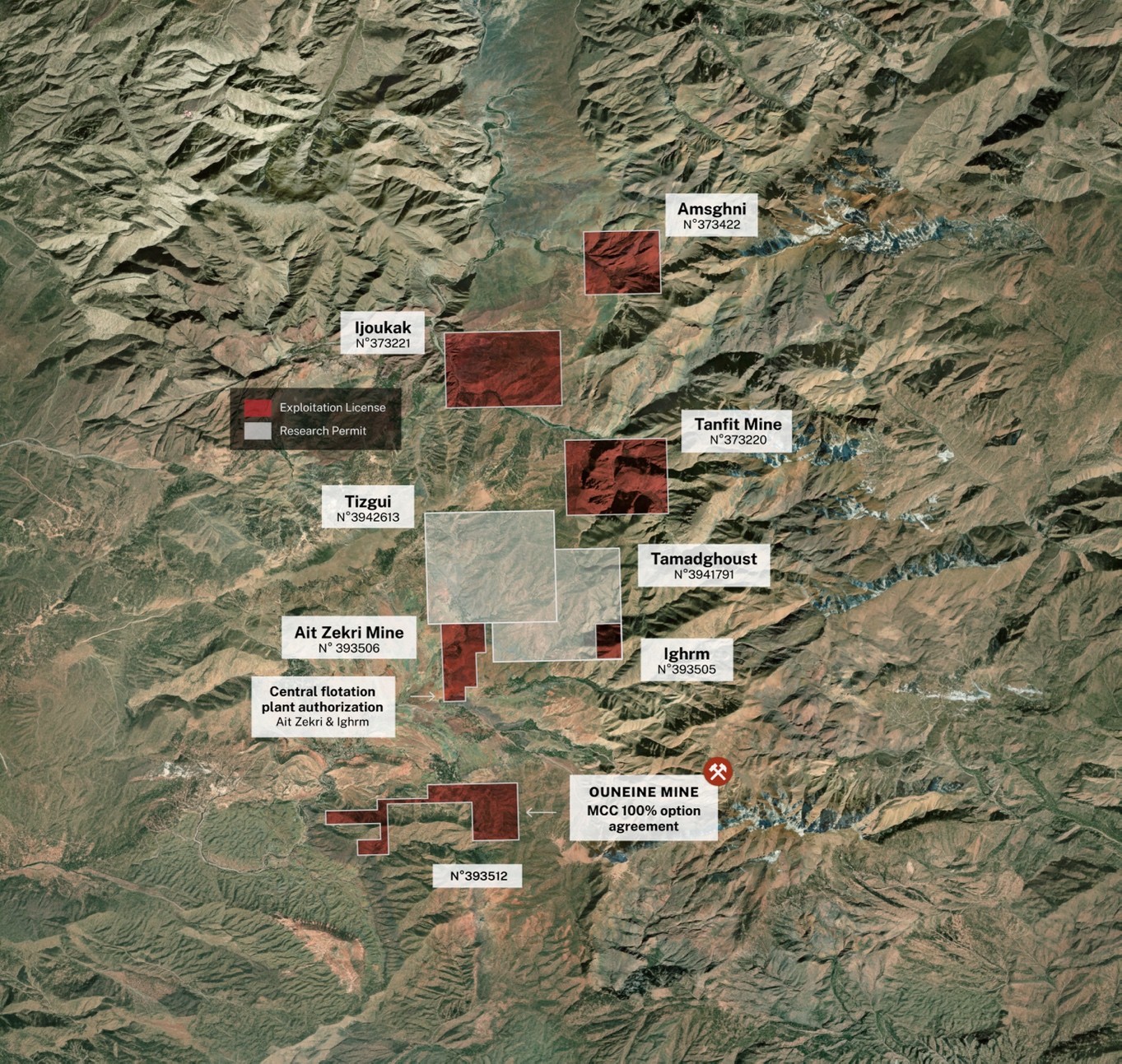
Figure 3: MCC’s Western High Atlas District showing the MNF optioned portfolio, the separately optioned Ouneine licence and the locations of the current Ouneine, Tanfit and Ijoukak exploration areas.
About Morocco Strategic Minerals
Morocco Strategic Minerals Inc. is a Canadian mineral exploration company focused on the acquisition, exploration, and, if warranted, development of natural resource properties of merit in Canada and Morocco.
Qualified Person
The technical and scientific information in this press release have been approved by Merouane Rachidi, Ph.D., P.Geo., an independent qualified person as defined in National Instrument 43-101 – Standards of Disclosure for Mineral Projects ("NI 43-101").
Sampling, Analytical Methods and Quality Assurance / Quality Control
All samples were submitted to the African Laboratory for Mining and Environment (Afrilab) in Marrakech, Morocco. Samples were analyzed for silver, copper, iron, lead and zinc using aqua regia digestion with an atomic absorption spectroscopy finish. Samples containing greater than 5% Cu were reanalyzed using titration, and gold was assayed by fire assay.
The Company’s QA/QC program includes the insertion of certified reference materials, blank samples and duplicate samples within the sample stream. Quality-control results are reviewed by the Company’s independent Qualified Person before analytical results are approved for public disclosure.
Contact Information
Pierre-Olivier Goulet
President and Chief Executive Officer
Email: info@moroccosm.com
Forward-Looking Statements and Disclaimer
Certain information contained herein may constitute “forward-looking information” under Canadian securities legislation. Forward-looking information includes, but is not limited to, statements regarding geological and structural interpretations; the potential orientation, continuity and extent of mineralization; the definition, validation and prioritization of drill targets; additional mapping, channel sampling, rehabilitation and three-dimensional modelling; access to historical workings; the timing and commencement of drilling; permitting and contractor availability; the exercise or maintenance of option rights; and the exploration and development potential of the Western High Atlas District.
Generally, forward-looking information can be identified by terminology such as “plans”, “expects”, “intends”, “may”, “will”, “could”, “should” or variations of such words and phrases. Forward-looking information is based on the Company’s estimates, expectations and assumptions as of the date of this release and is subject to known and unknown risks, uncertainties and other factors that may cause actual results or events to differ materially from those expressed or implied.
Readers should not place undue reliance on forward-looking information. The Company undertakes no obligation to update or revise such information except as required by applicable securities laws.
Neither the TSX Venture Exchange nor its Regulation Services Provider, as that term is defined in the policies of the TSX Venture Exchange, accepts responsibility for the adequacy or accuracy of this news release
Photos accompanying this announcement are available at
https://www.globenewswire.com/NewsRoom/AttachmentNg/e28f973e-52c3-4202-8e0c-c908e1f3daa0
https://www.globenewswire.com/NewsRoom/AttachmentNg/669c537b-dc68-4891-8e41-9e0420fbbd7b
https://www.globenewswire.com/NewsRoom/AttachmentNg/a17ede5e-9b65-4851-a4fb-9c767f6508ef


Figure 1
Figure 1: Plan of Ouneine Gallery A showing the locations, sampled lengths and average composite copper grades of each underground channel section.
Figure 2
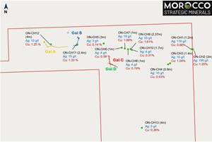
Figure 2: Ouneine surface channel locations and average copper-silver results for each channel sample.
Figure 3
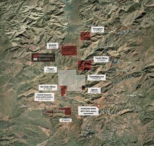
Figure 3: MCC’s Western High Atlas District showing the MNF optioned portfolio, the separately optioned Ouneine licence and the locations of the current Ouneine, Tanfit and Ijoukak exploration areas.
Legal Disclaimer:
EIN Presswire provides this news content "as is" without warranty of any kind. We do not accept any responsibility or liability for the accuracy, content, images, videos, licenses, completeness, legality, or reliability of the information contained in this article. If you have any complaints or copyright issues related to this article, kindly contact the author above.
